Category Archives: Ferry Ports

Zverinac Ferry Port

Croatian name: Zverinac

Pronounced as: Zverinats

Address: 23286 Zverinac, Croatia

Phone: + 385 23 250 565

Website (HR)

Zverinac ferry port is connected to the following ports:

Bozava, Ist, Molat, Rivanj, Sestrunj, Zadar

Map:

Below is the exact location of Zverinac on the map. You can zoom in to see more details.

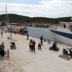
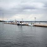
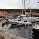
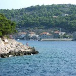
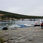
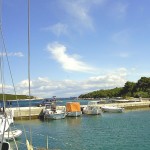
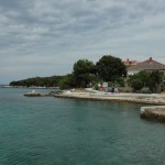
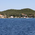
Zverinac Ferry Port Gallery

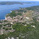
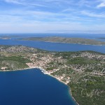
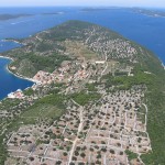
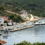
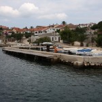
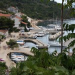
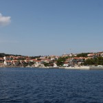
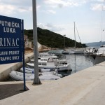
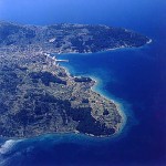
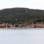
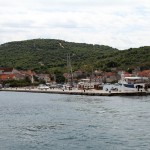
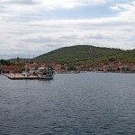
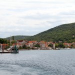
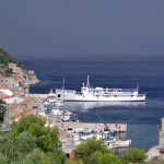
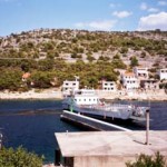
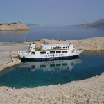
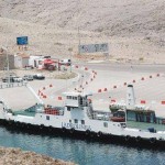
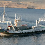
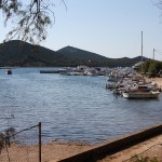
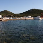
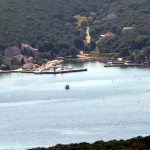
Zverinac ferry port is the primary maritime gateway to the small island of Zverinac, located in the Zadar archipelago. The port connects the island with the Croatian mainland, providing transport for residents, visitors, and local goods. Its location allows travelers to quickly access Zverinac’s beaches, walking paths, and the small village at the harbor.

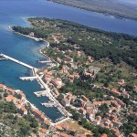
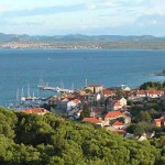
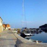
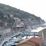
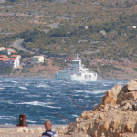
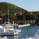
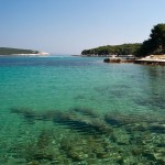
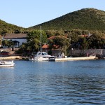
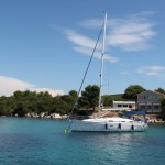
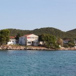
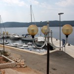
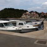
The port is nestled in a sheltered bay, offering calm waters and views of the surrounding Adriatic Sea. Ferries arrive regularly from the mainland, while small fishing boats and private vessels move through the harbor. The waterfront features a handful of stone houses and local shops, giving travelers a sense of the island’s quiet charm.

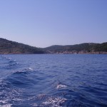
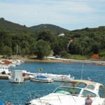
From Zverinac ferry port, visitors can explore nearby beaches, secluded coves, and the island’s scenic trails. The port acts as a convenient starting point for experiencing Zverinac’s natural surroundings and relaxed atmosphere, making it an inviting entry point for those seeking a peaceful Adriatic getaway.

About Zverinac and nearby areas

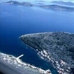
Zverinac is a small Croatian island in the Zadar Archipelago of the Adriatic Sea. Zverinac is located along the north-eastern shore of Dugi otok, opposite to Božava, with which it is connected by a passenger road. Administratively it belongs to the municipality of Sali. A place of the same name on the island is especially interesting for navigators because of the beautiful environment and for being secluded.

It occupies 4.2 square kilometres and is populated by 48 people, with a population density of 11.429 persons per square kilometer. Its highest peak is 111 metres high. Because of its size, the best way for visitors to get to know the place and the island Zverinac, is by taking a walk and experience complete peace and relaxation in untouched nature.

Zlarin Ferry Port

Croatian name: Zlarin

Website (HR)

Website (EN)

Zlarin ferry port is connected to the following ports:

Kaprije, Prvic Luka, Sepurine, Sibenik, Vodice, Zirje

Map:

Below is the exact location of Zlarin on the map. You can zoom in to see more details.

Zlarin Ferry Port Gallery

About Zlarin and nearby areas

Zlarin is a small island of the Dalmatian coast of Croatia near the city of Šibenik. Administratively, it is part of the Šibenik-Knin County. In winter times the island has a population of 276 people, but from March to October its population grows substantially up to 1,500 people.

The port is located in the natural bay in the north-western part of the island of Zlarin. It is naturally protected from most winds, with the exception of winds blowing from the west and northwest. This port has more landing quays and quaysides with berths for smaller boats than any other.

The port has 375 m of stone and concrete quay with berths for smaller boats. At the entrance of the bay, at the head of the largest landing quay, stands a SOLAR-POWERED beacon ( Red flash 0,5 + 2,5 sec. 3 NM ).

  • North side – has berths for passenger boats (from the head of the wharf to the middle), and berths for excursion boats (from the middle of the wharf to the base).
  • South side – has berths for powerboats, yachts, excursion and fishing boats and small crafts.

Žirje Ferry Port

English name: Zirje

Croatian name: Žirje

Pronounced as: Zheerye

Website (HR)

Website (EN)

Žirje ferry port is connected to the following ports:

Kaprije, Šibenik, Zlarin

Map:

Below is the exact location of Žirje on the map. You can zoom in to see more details.

Žirje Ferry Port Gallery

About Žirje and nearby areas

Žirje is an island and a settlement in the Croatian part of the Adriatic Sea. It is situated in the Šibenik archipelago, about 22 km southwest of Šibenik, which makes it the most distant permanently inhabited island in the Šibenik archipelago. The island is composed of two limestone ridges between which is a fertile valley. Its area is 15.06 km2, and it has a population of 94 (2011 census).

The harbour of Luka Muna is situated half way along the NE-facing coast of the island of Žirje in Croatia. The harbour consists of a small, V-shaped inlet quayed at its head and protected from NW by a breakwater which also acts as the ferry jetty, and features a stone and concrete landing wharf with breakwater, 60 m in length. Visiting yachts can tie up alongside or, at busy times, stern or bows-to using their anchor on the quay SE of the breakwater or, when a ferry is not due, alongside the ferry jetty. The inlet is protected in winds from most directions but is open NW.

Žigljen Ferry Port

English name: Zigljen

Croatian name: Žigljen

Pronounced as: Zheegljen

Address: Zigljen bb, Zigljen, 23250 Pag, Croatia

Žigljen ferry port is connected to the following ports:

Prizna

Map:

Below is the exact location of Žigljen on the map. You can zoom in to see more details.

Žigljen Ferry Port Gallery

The ferry port of Žigljen sits on the eastern coast of Pag Island and serves as the main gateway between the island and the mainland via the short but vital route to Prizna. It’s the terminus of route 335, and during peak season it handles upwards of one million passengers and 300 000+ vehicles annually.

Historically, it faced serious challenges: the fierce bora wind in the Velebit Channel and the rough seas often disrupted service. To combat this, a major reconstruction from 2020-2023 expanded the port with new ramps, three 120-metre ferry berths, reinforced mooring and wider maneuvering bay.

Today, Žigljen is far more reliable and efficient. Cars and passengers board quickly, waiting times drop, and the link to the mainland is stronger than ever. If you plan travel to Pag Island, this port is your first impression — therefore, expect brisk loading, seagulls scavenging, and possibly a gusty wind reminding you of where you are.

Zapuntel Ferry Port

Croatian name: Zapuntel

Pronounced as: Zapoontel

Address: Uvala Zapuntel, 23292 Molat, Croatia

Phone: + 385 23 250 565

Website (HR)

Zapuntel ferry port is connected to the following ports:

Brgulje, Ist, Molat, Zadar

Map:

Below is the exact location of Zapuntel on the map. You can zoom in to see more details.

Zapuntel Ferry Port Gallery

Zapuntel ferry port is the main access point to the small island of Zapuntel, part of the Zadar archipelago. The port links the island with the mainland, providing transport for residents, visitors, and local goods. Its location allows travelers to reach the island’s beaches, walking paths, and quiet village areas quickly after arrival.

The port is situated in a calm bay, offering views of the surrounding Adriatic waters and neighboring islands. Ferries arrive regularly from the mainland, while small fishing boats and private vessels navigate the harbor. The waterfront is modest, with a few local shops and houses, giving travelers a sense of the island’s peaceful character.

From Zapuntel ferry port, visitors can explore the island’s beaches, natural landscapes, and small villages. The port serves as a convenient starting point for discovering Zapuntel’s serene environment, making it an ideal entry point for those seeking a quiet Adriatic escape.

About Zapuntel and nearby areas

Molat Island lies off the mainland coast of Croatia, two miles NE of the island of Dugi Otok and 17 miles NW of the port of Zadar. Shaped rather like an arrowhead, the island has an area of just under 23 square kilometers, supporting just three small settlements: Molat (population 107), Zapuntel (pop. 42) and Brgulje (pop. 48), and they are situated in the interior of the island, and only smaller hamlets are on the seaside. In consequence, the shoreline of the island supports only small harbors or jetties with little habitation around them. Inhabitants of Molat support themselves by agriculture, sheep rearing, fishing and, increasingly, tourism, including yachting tourism.

There are just two (more or less) organized berthing facilities: the quay and laid moorings of Uvala Lucina, the small harbour which serves the settlement of Molat Town, and the mooring buoys of Uvala Vrulje, which is the sea outlet of the village of Brgulje.

Zaglav Ferry Port

Croatian name: Zaglav

Address: 23281 Zaglav, Dugi Otok, Croatia

Phone: +385 23 250 565

Website (HR)

Zaglav ferry port is connected to the following ports:

Zadar, Sali

Map:

Below is the exact location of Zaglav on the map. You can zoom in to see more details.

Zaglav ferry port sits on the southeastern coast of Dugi Otok, one of Croatia’s most beautiful Adriatic islands. It’s a small but crucial transport hub connecting the island to the city of Zadar on the mainland. Surrounded by clear blue waters and green hills, the port offers a postcard-worthy view that feels straight out of a travel magazine.

Despite its laid-back look, Zaglav handles steady ferry traffic year-round. It’s the main entry point for cars and goods heading to Dugi Otok, supporting both residents and the island’s growing number of tourists. The Jadrolinija ferry line keeps a regular schedule, making it easy for travelers to explore the island’s beaches, salt lakes, and fishing villages without stress.

The port itself is simple—one pier, a few buildings, and a calm waiting area where time seems to slow down. But what it lacks in size, it makes up for in charm. Watching the ferries dock as locals exchange greetings gives Zaglav the feel of a small-town train station—only with sea spray and seagulls instead of steam and whistles.

Zadar Ferry Port

Croatian name: Zadar

Address: Obala Kralja Tomislava, 23000 Zadar, Croatia

Website (HR)

Website (EN)

Zadar ferry port is connected to the following ports:

Bozava, Brbinj, Brgulje, Brsanj, Ilovik, Ist, Krijal, Mala Rava, Mali Iz, Mali Losinj, Molat, Olib, Preko, Premuda, Pula, Rava, Rivanj, Sali, Sestrunj, Silba, Unije, Veli Iz, Zaglav, Zapuntel, Zverinac

Map:

Below is the exact location of Zadar on the map. You can zoom in to see more details.

Zadar ferry port is one of the key maritime hubs on Croatia’s Adriatic coast, linking the mainland with numerous islands in the Zadar archipelago as well as international destinations. The port serves passengers, vehicles, and cargo, supporting both local residents and a thriving tourist industry. Its central location provides convenient access to the city’s historic center, beaches, and waterfront, making it a vital gateway to northern Dalmatia.

The harbor is located in a naturally protected area, offering calm waters and panoramic views of the surrounding coastline. Ferries regularly depart for islands such as Dugi Otok, Ugljan, and Pasman, while smaller boats and private vessels navigate the harbor. The waterfront features modern facilities alongside historic buildings, creating a mix of contemporary functionality and old-world charm for arriving travelers.

Zadar ferry port also provides access to the city’s cultural attractions. Visitors can explore the Roman Forum, St. Donatus Church, and the city’s ancient walls shortly after disembarking. The port area itself is lively, with cafés, restaurants, and small shops lining the harbor, offering travelers a place to relax or gather supplies before heading out to the islands.

The port’s connectivity makes it an ideal starting point for island excursions. Travelers can take ferries to secluded beaches, coves, and villages on nearby islands, or enjoy day trips to explore the archipelago’s natural beauty. Sailing and boating activities are common, and the port serves as a hub for those seeking both adventure and relaxation along the northern Dalmatian coast.

For business and transport purposes, Zadar ferry port handles cargo shipments and vehicles, connecting the mainland with the islands efficiently. Its strategic location also supports seasonal tourism, accommodating the influx of visitors during the summer months and providing easy access to accommodation and transport services in the city.

Zadar ferry port combines historical surroundings with modern maritime operations. The harbor’s proximity to the old town, scenic views of the sea, and access to nearby islands make it a central point for both local travel and tourism. Visitors arriving at the port immediately encounter a mix of Adriatic charm, cultural heritage, and coastal beauty, making it a gateway to the diverse experiences of Zadar and its surrounding islands.

Vodice Ferry Port

Croatian name: Vodice

Address: 22211 Vodice, Croatia

Website (HR)

Website (EN)

Vodice ferry port is connected to the following ports:

Prvic, Sepurine, Sibenik, Zlarin

Map:

Below is the exact location of Vodice on the map. You can zoom in to see more details.

Vodice ferry port sits along the vibrant Dalmatian coast, serving as the main link between the town and nearby islands. Though smaller than major ports, it handles steady passenger and vehicle traffic, especially during the summer tourist season. The port offers easy access to destinations like Prvić, Zlarin, and other islands in the Šibenik archipelago, making it a key hub for local travel.

The port is straightforward and functional, with a few berths for ferries and catamarans. Travelers can expect smooth boarding, quick departures, and scenic views of the Adriatic as ferries glide across the water. Its proximity to the town center allows for a relaxed stroll or a quick coffee before setting off.

For visitors, Vodice ferry port is more than just a transit point. It provides a glimpse of local life, with fishermen preparing boats, seagulls overhead, and travelers loading vehicles. The surrounding coastline and clear waters make it a charming starting point for island adventures, combining convenience with a taste of Dalmatian coastal charm.

Vis Ferry Port

Croatian name: Vis

Pronounced as: Vees

Address: Obala Svetog Jurja, 21480 Vis, Croatia

Website (EN)

Vis ferry port is connected to the following ports:

Hvar, Split

Map:

Below is the exact location of Vis on the map. You can zoom in to see more details.

Vis ferry port is the main gateway to the island of Vis, located off Croatia’s Dalmatian coast. It connects the island to the mainland town of Split, providing vital transport for both residents and visitors. The port is a hub for passenger ferries and cargo vessels, ensuring the smooth flow of goods and travelers while offering stunning views of the Adriatic Sea.

The port is well-equipped, with multiple berths and organized boarding areas that make arrivals and departures efficient. During the summer months, ferries run more frequently to accommodate tourists eager to explore Vis’s beaches, historic sites, and vineyards. The calm waters and sheltered bay make it an ideal spot for docking, even in rougher weather.

Beyond its functional role, Vis ferry port has a laid-back charm. Travelers often enjoy watching local fishermen at work or spotting small boats gliding across the water. With its proximity to the town center, visitors can easily grab a coffee or take a short stroll along the waterfront before heading to their island adventures.

Veli Iž Ferry Port

English name: Veli Iz

Croatian name: Veli Iž

Pronounced as: Velee Izh

Address: Veli Iz, 23284 Iz, Croatia

Phone: + 385 23 250 565

Website (HR)

Veli Iž ferry port is connected to the following ports:

Mala Rava, Mali Iz, Rava, Zadar

Map:

Below is the exact location of Veli Iž on the map. You can zoom in to see more details.

Veli Iz ferry port is the main connection between the small island of Iz and the Croatian mainland. Nestled on the island’s eastern shore, it serves as the primary point for passenger ferries and small cargo vessels traveling to and from Zadar. Despite its modest size, the port plays a crucial role in daily life for residents and visitors alike.

The port is simple but functional, with a single quay for ferries and an organized boarding area. Ferries run on a regular schedule, ensuring smooth travel for locals commuting to the mainland and tourists exploring the island. The surrounding waters are calm, making arrivals and departures straightforward even in less favorable weather.

Veli Iz ferry port offers more than transit—it provides a glimpse into island life. Travelers can watch fishermen at work, enjoy the peaceful waterfront, or take in the scenic views of the Adriatic. Its small size and relaxed pace make it a welcoming introduction to the charm and quiet beauty of Iz Island.